 FAO Map Catalog
West Africa
Type of resources
Available actions
Topics
Keywords
Contact for the resource
Provided by
Years
Formats
Representation types
Update frequencies
status
Scale
-
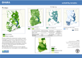
This dataset represents the second-level administrative unit 'Sectores' of Guinea-Bissau. The dataset was uploaded by the Direcção Geral de Geografia e Cadastro of Guinea-Bissau in September, 2021 to Second Administrative Level Boundaries (SALB) Program of United Nations. The reference scale for this Geospatial data is equivalent to 1:1,000,000 scale, or larger scale. Data was downloaded from UN-SALB site in September 2022, feature topology/geometry was corrected, international borders validated against the United Nations official borders (United Nations Geospatial Information Section - UN-Map 2018). The dataset is part of FAO's Hand-in-Hand (HiH) second administrative level boundaries 2022 dataset series, published on the HiH Geospatial Platform for thematic mapping, integration of geospatially enabled statistics, zonal statistics extraction, and used for HiH initiative geospatial analysis (GIS-MCDA, suitability/location analysis, agricultural typologies).
-
This dataset represents the second-level administrative unit 'Districts' of Ghana. The dataset was uploaded by the Lands Commission of Ghana in October 2021 to Second Administrative Level Boundaries (SALB) Program of United Nations. The reference scale for this Geospatial data is equivalent to 1:1,000,000 scale, or larger scale. Data was downloaded from UN-SALB site in September 2022, feature topology/geometry was corrected, international borders validated against the United Nations official borders (United Nations Geospatial Information Section - UN-Map 2018). The dataset is part of FAO's Hand-in-Hand (HiH) second administrative level boundaries 2022 dataset series, published on the HiH Geospatial Platform for thematic mapping, integration of geospatially enabled statistics, zonal statistics extraction, and used for HiH initiative geospatial analysis (GIS-MCDA, suitability/location analysis, agricultural typologies).
-
This dataset represents the second-level administrative unit 'Departments' of Niger. The dataset was uploaded by the Institut Géographique National under Ministère de l'Urbanisme et du Logement of Niger in January, 2022 to Second Administrative Level Boundaries (SALB) Program of United Nations. The reference scale for this Geospatial data is equivalent to 1:1,000,000 scale, or larger scale. Data was downloaded from UN-SALB site in July 2022, feature topology/geometry was corrected, international borders validated against the United Nations official borders (United Nations Geospatial Information Section - UN-Map 2018). The dataset is part of FAO's Hand-in-Hand (HiH) second administrative level boundaries 2022 dataset series, published on the HiH Geospatial Platform for thematic mapping, integration of geospatially enabled statistics, zonal statistics extraction, and used for HiH initiative geospatial analysis (GIS-MCDA, suitability/location analysis, agricultural typologies).
-
This dataset represents the second-level administrative unit 'Departments' of Cameroon. The dataset was prepared by the Institut National de Cartographie of Cameroon in February 2021 to Second Administrative Level Boundaries (SALB) Program of United Nations. The reference scale for this Geospatial data is equivalent to 1:1,000,000 scale, or larger scale. Data was downloaded from UN-SALB site in December 2022, feature topology/geometry was corrected, international borders validated against the United Nations official borders (United Nations Geospatial Information Section - UN-Map 2018). The dataset is part of FAO's Hand-in-Hand (HiH) second administrative level boundaries 2022 dataset series, published on the HiH Geospatial Platform for thematic mapping, integration of geospatially enabled statistics, zonal statistics extraction, and used for HiH initiative geospatial analysis (GIS-MCDA, suitability/location analysis, agricultural typologies).
-
This dataset represents the second-level administrative unit 'Cercles' of Mali. Mali is divided into eight regions and one capital district (Bamako); those are subdivided into 55 cercles. The dataset was uploaded by Institut Géographique du Mali, National Geospatial Information Authority in September 2021 to Second Administrative Level Boundaries (SALB) Program of United Nations. The reference scale for this Geospatial data is equivalent to 1:1,000,000 scale, or larger scale. Data was downloaded from UN-SALB site in May 2022, feature topology/geometry was corrected, international borders validated against the United Nations official borders (United Nations Geospatial Information Section - UN-Map 2018). The dataset is part of FAO's Hand-in-Hand (HiH) second administrative level boundaries 2022 dataset series, published on the HiH Geospatial Platform for thematic mapping, integration of geospatially enabled statistics, zonal statistics extraction, and used for HiH initiative geospatial analysis (GIS-MCDA, suitability/location analysis, agricultural typologies).
-
This dataset represents the second-level administrative unit 'regions' of Côte d'Ivoire. There are 14 districts and autonomous districts. Except for the two autonomous districts around the cities of Yamoussoukro and Abidjan, the remaining 12 autonomous districts are further subdivided into 31 regions. The dataset was uploaded by the Centre d'Information Géographique et du Numérique (BNETD) in January, 2022 to Second Administrative Level Boundaries (SALB) Program of United Nations. The reference scale for this Geospatial data is equivalent to 1:1,000,000 scale, or larger scale. Data was downloaded from UN-SALB site in June 2023, feature topology/geometry was corrected, international borders validated against the United Nations official borders (United Nations Geospatial Information Section - UN-Map 2018). The dataset is part of FAO's Hand-in-Hand (HiH) second administrative level boundaries 2022 dataset series, published on the HiH Geospatial Platform for thematic mapping, integration of geospatially enabled statistics, zonal statistics extraction, and used for HiH initiative geospatial analysis (GIS-MCDA, suitability/location analysis, agricultural typologies).
-
This dataset represents the second-level administrative unit 'arrondissements' of Senegal. There are 45 arrondissements under 14 regions. The dataset was uploaded by the Agence Nationale de l'Aménagement du Territoire, Senegal in August, 2021 to Second Administrative Level Boundaries (SALB) Program of United Nations. The reference scale for this Geospatial data is equivalent to 1:1,000,000 scale, or larger scale. Data was downloaded from UN-SALB site in January 2022, feature topology/geometry was corrected, international borders validated against the United Nations official borders (United Nations Geospatial Information Section - UN-Map 2018). The dataset is part of FAO's Hand-in-Hand (HiH) second administrative level boundaries 2022 dataset series, published on the HiH Geospatial Platform for thematic mapping, integration of geospatially enabled statistics, zonal statistics extraction, and used for HiH initiative geospatial analysis (GIS-MCDA, suitability/location analysis, agricultural typologies).
-
This dataset represents the second-level administrative unit 'communes' of Benin. There are 77 communes under 12 departments. The dataset was uploaded by the Institut Géographique National du Bénin in September, 2021 to Second Administrative Level Boundaries (SALB) Program of United Nations. The reference scale for this Geospatial data is equivalent to 1:1,000,000 scale, or larger scale. Data was downloaded from UN-SALB site in June 2023, feature topology/geometry was corrected, international borders validated against the United Nations official borders (United Nations Geospatial Information Section - UN-Map 2018). The dataset is part of FAO's Hand-in-Hand (HiH) second administrative level boundaries 2022 dataset series, published on the HiH Geospatial Platform for thematic mapping, integration of geospatially enabled statistics, zonal statistics extraction, and used for HiH initiative geospatial analysis (GIS-MCDA, suitability/location analysis, agricultural typologies).
-
This map shows areas suitable for the Agricultural Water Management interventions as identified by the project. The assessment is based primarily on each intervention's bio-physical requirements (such as: climate, proximity to water resources, terrain), but it also includes a qualitative rating based on infrastructural settings (namely distance to markets).
-
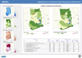
This map shows where AWM can be the entry point for improving livelihoods and where to prioritize investments in AWM to have the maximum impact on rural livelihoods. High potential areas are those showing the highest potential for AWM investment. These areas are identified on the basis of three guiding principles: 1) where water is available 2) where the target beneficiaries are mostly located; and 3) where water is key for livelihoods.